Saturday, July 31, 2010

more Dawson

Sorry, this picture was meant to be in the group of pix of Dawson City, and not two of the same crooked buidings. Must be tired. Enough!

PS I am up on Laurie in Cribbage, by 2 games!
Posted by Picasa

Dawson City 4

Ooops, the computer gremlins deleted this picture of Robert Service's cabin.

So, now we are up to date. Heading out on the Dempster tomorrow, Saturday. It is unlikely we will be able to update until we get back to Dawson in 4-6 days!

Oh, by the way. Dear Blog readers, did you know that if you click on the pictures, they will enlarge for you?
Posted by Picasa

Dawson City 3


After the trip out to the Dredger #4 we stopped in town to get groceries and check with the NWT Info centre - The Dempster is open! Then we went on to see some more historical sites. The first cabin is a recreation from some of the original logs of a cabin that Jack London stayed in trying to make his fortune in the gold rush (he didn't) It apparently is where he found the basis for his more well known books "White Fang" and "Call of the Wild". Note the grass growing on the roof.
I remember my Granny and Grandad Hoye lived in a 1 room soddie in the prairies, I think even with Frank as a baby. Boy, I sure could not have done that!
The second cabin, is reportedly the cabin that Robert Service lived in while he wrote poetry such "the Cremation of Sam McGee". It actually had 2 rooms, but we missed the tour/poetry quoting session. We were quite impressed with the raspberry canes growing on his roof.

We could totally see Alan (Sara's Dad) doing this gig.

Later today we had the privilege of attending the Moosehide Gathering - a bi-annual weekend gathering by the local first nations. They had a well organized system of boats that whisked us down the Yukon river to their summer camp. They had performers and small craft booths and more than 400 people attending for a free dinner of salmon, moose stew, turkey and ham and salads and baked potatoes and dessert and we are stuffed! We really enjoyed the visit and the atmosphere. Apparently many of the neighboring first nations attended, and they treated the elders with such respect.

On the way back up the Yukon river, we saw this wreck - an old stern wheeler?
Posted by Picasa

Dawson City 2


Last night we went to Diamond tooth Gerties - a fun production within a gambling casino complete with black jack tables, Texas hold 'em tables and slot machines. Quite enjoyed the performance with the dancers and singers.

Afterwards we walked back along the river. This is the old CIBC building right along the water, and this picture was taken about 10:30 pm.

Today, Friday, we went out to Dredger #4 up the Bonanza river. It is another Parks Canada historical site. They actually have restored this beast, in its time the largest dredger in the world. Our pictures don't do it justice. It was huge, and up until the past 5 years was frozen in a swamp. The action was pretty basic, they had to melt the permafrost and then dig down to bedrock and sort the gravel/ mud in the big roller (kind
of how a front loading washing machine works. Anyway the heavy gold fell through the holes first, and then the water washed it all over sluices so that the gold could be collected. The thing must have made an incredible racket, and left huge trails (tailings) of gravel all up and down the valleys.
Posted by Picasa

Dawson City 1


We arrived in Dawson City relatively early on Thursday, Laurie being quite clever at figuring out we should be here early to get a camp site. We chose the campsite in the downtown area, which meant we could walk to almost everything (and run along the Yukon river in the morning - how cool is that!)

As many of you know, Dawson sits on permafrost so house construction has to accommodate this and it was as interesting to look at the old buildings as it was to look at the new construction, up on blocks with a skirt around them - no basements! We took a walking tour done by Parks Canada - they own and operate several historic sites here. Our guide was a lovely french Canadian gal, who made the 1.5 hour tour interesting and educational
We checked in with the NWT Information people, and the Dempster was still closed as of yesterday, (a creek crossing was washed out).
We quickly decided that we needed another day here to see the sights.

The old buildings are slowly sinking into the ground, some have been resurrected, many replaced. Brand new school.
Posted by Picasa

Faro to Dawson City

This is our first view of the Yukon River. Pretty impressive, flowing north to the Bering Sea. We stopped at a Territorial campsite at Moose Creek. I loved it, because it hummed. All evening you could hear the bees in the trees. Apparently this is a bumper crop year for wasps! (Although they have not been a big problem for us)

I asked Laurie to take this picture at 6 pm
The above picture is at 10:30 p.m. - Barb with her first marshmallow of the trip!
The last picture is taken by Laurie, who stayed up 'til midnight. It really is weird to go to bed and its still light enough to read outside at midnight.
Posted by Picasa

road from Watson Lake to Faro

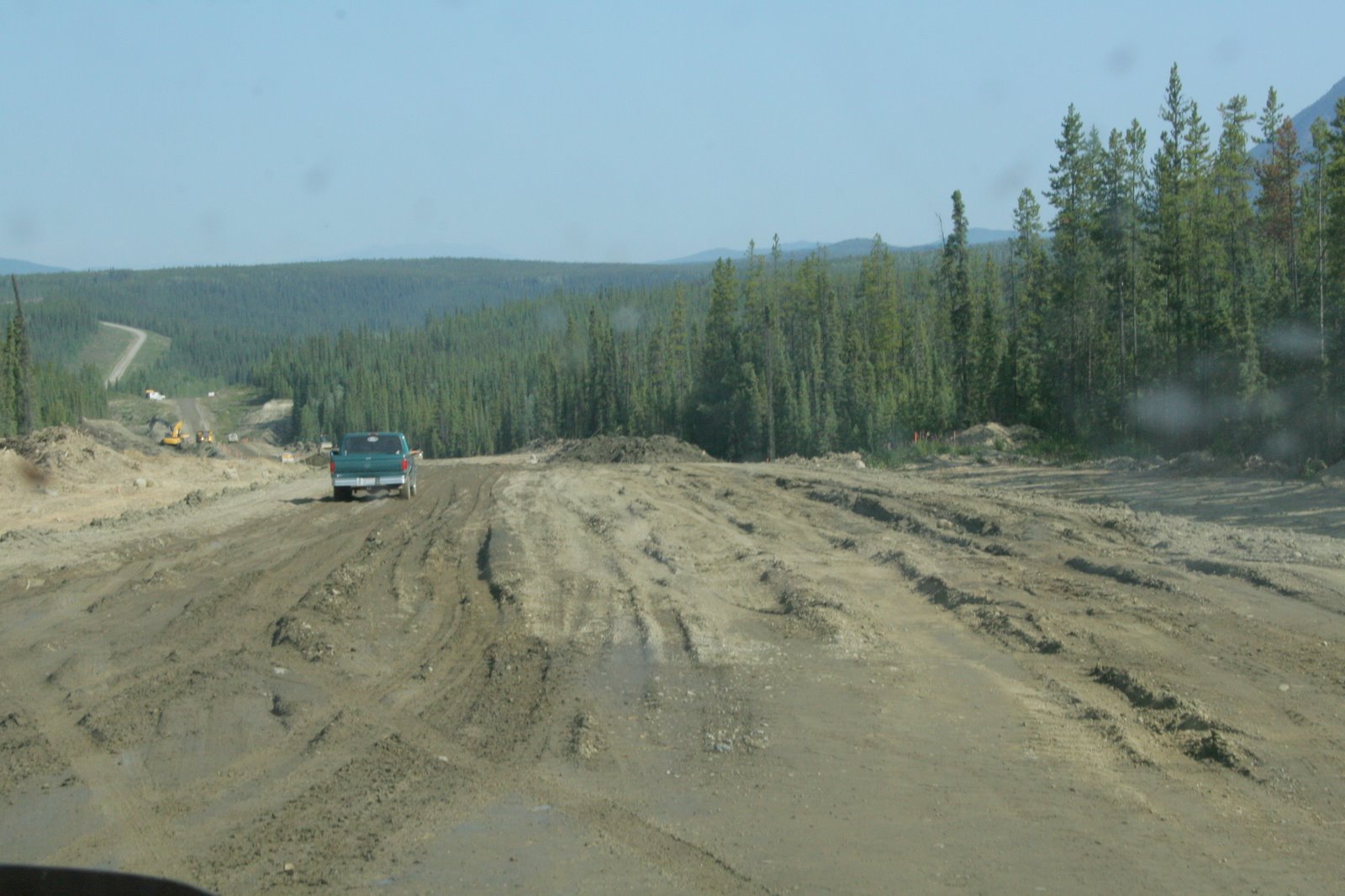
This is a large part of what the road was like, only much worse. Barb couldn't take any more pictures because she was hanging on . It was under construction for about 30 km, again good practice for the Dempster. It was somewhere along here that we developed a slow leak = completely flat by morning (and we had had it pumped up the night before).
This is called the Campbell highway, often only 1 car width and gravel was an improvement! This 200km piece of road took us all day and was relatively boring except for the terrifying near miss with the speeding truck that jack-knifed on the crest of a hill!
Once we got to Faro, we found it to be a beautiful little town (very little, I was able to run my 1/2 hour run around the whole town. The information centre had wifi (hence the quick note previously). We were able to hike up to this waterfall out the back of the campsite, again looking for the Dall sheep (with the curly horns) but no luck.
The town of Faro also had this outdoor fitness centre that was pretty good. On one machine I could lift my own weight by my arms, in another it was a typical eliptical but all were designed to tolerate living outdoors. And apparently no vandalism.
The golf course wound its way throughout the town, wherever there was green space. Didn't get to play it unfortunately.
The next morning we drove 18 km in/out on a tiny road to a sheep blind - still no sheep.
Posted by Picasa

Friday, July 30, 2010

Bison!

These bison were just lying around, at the side of the road. Later in our travels we saw a herd running beside the road, quite a sight!
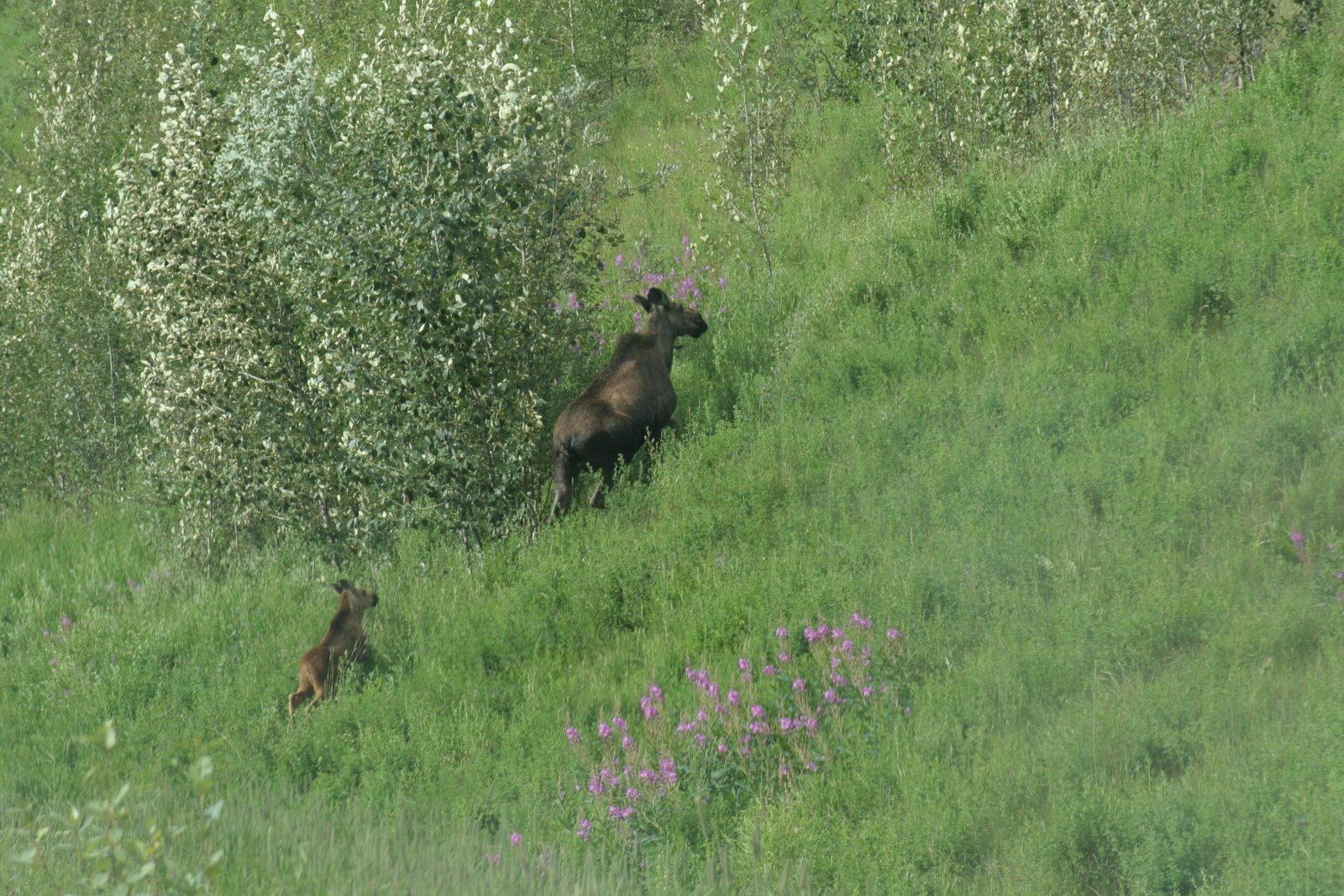
We noticed this guy had a very large collar, presumably the style for late night soirees in northern BC. I thought it was a little ostentatious, none of his buddies or ladies had one. Perhaps the one above was jealous (or maybe more comfortable!). We figure human (?) resources are keeping track of his tracks
Posted by Picasa

more critters

These are stone sheep, they like to be on the side (or middle) of the road - to lick the salt? But were used to having the tourists gawk and take pictures. Sorry, they are a little fuzzy, the camera took a knock as we rounded the corner and suddenly there they were!
The scenery on this part of the trip was pretty spectacular with big, clear rivers and soaring peaks.

As Laurie mentioned, the Hot springs at Liard River PP were lovely. Benches in the "pool" (naturally formed basin) were perfect for a good soak.
Posted by Picasa

Laurie's week 2 synopsis


Lots of driving, lots of wildlife, Laird River Hot Springs was a great place to stop and relax. The are 2 pools, the top end of the lower pool is smoking hot. Watson Lake's "Sign Forest" was amazing - 67,000 signs. Highway 4 from Watson Lake to Carmack was a poor choice. We knew that it was gravel but not like a narrow 2 lane country road, lots of pot holes, and incredibly dusty. Almost got smoked by a jackknifing 18 wheeler at a crest of a hill, and the Tire Gods didn't like my left rear tire. Did I mention it was also boring. The only redeeming feature of this road was about 7 km's of construction where we had to use 4 wheel drive. Tire was fixed by the Faro Public Works people who were great.
Posted by Picasa

Thursday, July 29, 2010

Fort Nelson to Liard Hotsprings Prov. Park 1


I am so pleased that we are able to show you some of the magnificent landscape we have seen in the past few days. I think these are elk, couldn't get them to turn around (my elk speak is poor), so now you have a good view of their rear ends! They were not the least bit concerned about us stopping to take their pictures. Muncho lake is just beautiful, with a couple of Provincial campsites beside it. To sit here and enjoy the view and quiet was lovely. Note the little tips of snow in the picture, first snow that we have noticed.

The camp site in Fort Nelson was not our favorite, no hot water in the showers, everything in shabby condition.

We ran into construction along the way and noted that the workers were really bundled up against the cold wind.
Posted by Picasa

catch up blog Dawson creek onward


So we have had some computing issues trying to upload pix and even getting regular wifi access. We are currently in Dawson City, YT, but will try to update blog with info on the trip thus far.

We saw momma moose and calf right on the road. We are heading towards Muncho Lake.
Posted by Picasa

Monday, July 26, 2010

Dawson Creek to Watson Lake

Having a problem uploading pix. Not sure why. Most annoying as we are now in Watson Lake, Yukon - and we have certainly seen some wild life. (Also can't get on Sympatico to check email). Just a tease until we can up load the pix, but we have seen deer, moose (cow and calf), elk, bison, Stone sheep, alligators and hippos - okay I may have fibbed about the last two. Amazing scenery, beautiful mountains, even some with snowy bits, and raging, huge rivers.
Tomorrow we take the Campbell highway through Ross River and Faro eventually we will come out at Carmacks and carry on to Dawson City. This may take a couple of days and it is most unlikely we will have wifi access.

Trunk running beautifully, Barb running every other day and Laurie running all other systems.
Easy day today, short drive, toured Watson Lake, more groceries and fuel. Forced to sit in the sun and read my book! 25 degrees, sunny - yahoo!!

Sunday, July 25, 2010

Map Update

Good heavens! So much driving!


View Mum and Dad's BFRT Adventure in a larger map

Saturday, July 24, 2010

Slave Lake to Dawson Creek


We camped at Lesser Slave Lake provincial park - a lovely campground with an amazing beach, warm weather (well a thunder storm rumbled around us but never developed) and no bugs! Laurie was thrilled to light his first bonfire and we found that it was still very light out at 10:00pm. On our way to LSLPP we drove 50 km through an area of a fairly recent forest fire (within the last 5 years) quite a vast tract of charred trees with small new growth.
Today, (Friday, 23/7/10) we headed northwest to Peace River. Saw 3 deer at the side of the road, thankfully, they had no interest in crossing in front of us! We diverted to Peace River because 45 years ago Laurie tested most of the upright tubes along the bridge. Apparently there had been some problems because the bridge deck had not been applied before it's first winter. (Laurie may have to correct this story). The area has several mighty rivers - (noteably the Athabascan and the Peace) and some beatiful valleys between the fields of grain. We stopped in Peace River to re-provision, thinking that the further north we go, the more expensive things will be.
In Dawson Creek we found the mile 0 marker for the Alaska Highway. At the Information centre they had an excellent movie about the building of the Alaska Highway and the amount of manpower used to get it done in a hurry in 1942/43. Tomorrow we head north to Fort Nelson.
Posted by Picasa